Volcano profile · Batangas, Luzon, Philippines
Taal
A vast caldera system hidden beneath a lake — capable of explosive magma-water interaction, ash columns, base surges, volcanic gas and rapid change across Volcano Island.
Latest activity and alert level
Check the live status hub
Taal can change quickly as magma, gas and water interact beneath Volcano Island. View the Volcoholics volcano directory for the latest verified official position from DOST-PHIVOLCS.
View latest Taal status →A volcano larger than it looks
Not a cone, but a caldera landscape
Taal is one of the Philippines’ most unusual active volcanoes because the visible Volcano Island is only a small part of the much larger volcanic system.
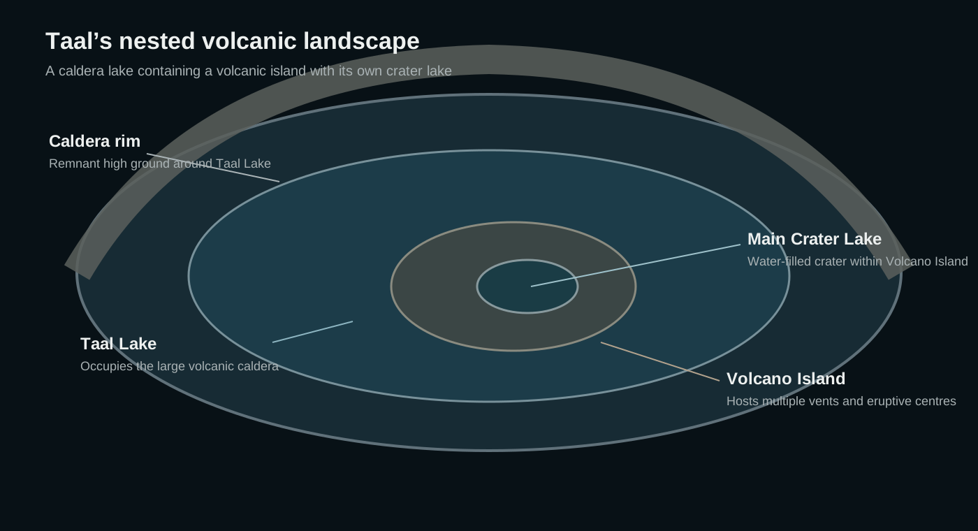
The broad Taal caldera is occupied by Taal Lake. Within that lake sits Volcano Island, itself containing the Main Crater and Main Crater Lake. Multiple eruptive centres, cones and fissures on Volcano Island record a long history of shifting vents.
This geometry matters. Water is present throughout the system, so magma can interact violently with lake or groundwater, producing highly fragmented ash and fast-moving base surges.
311 mVolcano Island summit
Caldera complexVolcanic setting
Volcano IslandPermanent Danger Zone
PHIVOLCSOfficial monitoring

Taal quick facts
- Volcanic setting
- Large caldera complex
- Location
- Batangas, Luzon, Philippines
- Central feature
- Volcano Island
- Main crater
- Main Crater Lake
- Official agency
- DOST-PHIVOLCS
Activity and behaviour
Gas, water and magma in a confined island system
Evergreen profile
How Taal behaves
Taal can produce phreatic, phreatomagmatic and magmatic eruptions. Water-rich conditions make explosive fragmentation especially important, while strong degassing and rapid changes in the crater system can create serious local hazards.
Check the latest verified status →Characteristic processMagma-water interactionRapid steam expansion can intensify fragmentation
Defining hazardBase surgesGround-hugging ash-rich currents can move rapidly
Persistent signalVolcanic gasStrong degassing can occur without a major eruption
Regional impactAshfallFine ash can affect large areas around the caldera
Official sourcePHIVOLCSAuthoritative alerts, bulletins and hazard guidance
A permanently hazardous island
Volcano Island is the Permanent Danger Zone
PHIVOLCS treats the whole of Volcano Island as a Permanent Danger Zone. Explosions, base surges, ballistic fragments, toxic gas and rapid crater changes can affect the island with little warning.
The nested lake system
A volcano inside a lake inside a caldera
Taal’s geography is the key to understanding its hazards.
The outer caldera is filled by Taal Lake. Volcano Island occupies the centre of that lake and contains multiple vents, including the Main Crater and its own crater lake. This nested arrangement places magma, groundwater and lake water in unusually close proximity.
Caldera rimHigh ground surrounding the broad collapse structure.
Taal LakeFills much of the ancient caldera.
Volcano IslandThe central eruptive complex with multiple vents.
Main Crater LakeA water-filled crater inside Volcano Island.
How Taal erupts
When magma meets water
At Taal, water can dramatically alter eruption style. Rapid heating and steam expansion fragment magma and surrounding rock, creating fine ash and powerful explosive currents.

Monitoring
Watching earthquakes, gas, water and deformation together
No single measurement defines Taal’s condition. PHIVOLCS combines multiple signals because changes in magma, gas, water and the shallow hydrothermal system can overlap.
A volcano through time
Taal eruption timeline
Prehistoric
Large caldera-forming eruptions
Repeated major explosive eruptions created the broad depression now occupied by Taal Lake.
Major historical eruption1754
Months of destructive activity
A prolonged eruption sequence reshaped parts of Volcano Island and severely affected communities around Taal Lake.
Deadly eruption1911
Powerful explosive eruption
A major eruption devastated Volcano Island and caused widespread fatalities around the lake.
1965
Base surge becomes a defining hazard
A violent phreatomagmatic eruption generated fast-moving base surges and became a classic case study in volcanology.
1977
Last eruption of the 20th century
Explosive activity continued the historical pattern of repeated unrest on Volcano Island.
Modern eruption2020
Ash column, lightning and regional disruption
A rapid escalation produced a high eruption column, widespread ashfall and intense electrical activity, forcing major evacuations around the lake.
2021–2022
Short explosive episodes and strong degassing
Phreatomagmatic bursts, gas emissions and changing crater conditions demonstrated that Taal’s unrest can remain hazardous even without a large sustained eruption.
Hazards
Taal’s hazards extend beyond the crater
Fast, turbulent clouds of ash, gas and debris can sweep across Volcano Island and nearby low areas.
Fine ash can travel far from the caldera and disrupt transport, agriculture and aviation.
Explosions can throw large blocks around active vents.
High sulfur dioxide output can create hazardous air quality and vog-like conditions.
Explosions, currents or slope failures can disturb the lake and generate local waves.
Deformation around the caldera can damage roads, structures and agricultural land.
Myths versus reality
Taal is easy to underestimate
The visible island is only the central part of a much larger caldera system.
At Taal, water can intensify fragmentation and drive violent phreatomagmatic explosions.
Taal can produce dangerous explosive activity dominated by ash, steam and gas without obvious lava flows.
Volcoholics insight
Taal is small only if you measure height
Its true scale is written across the lake. The central island, crater lake, caldera rim and surrounding communities all belong to one volcanic system — a reminder that the most important dimension of a volcano is not always vertical.
Questions answered
Taal explained
Where can I find Taal’s latest official status?
Use the Volcoholics volcano directory for the latest verified summary, then follow DOST-PHIVOLCS for authoritative alert levels, bulletins, exclusion zones and hazard guidance.
Is Volcano Island the whole volcano?
No. Volcano Island sits inside Taal Lake, which itself occupies a much larger volcanic caldera.
Why are Taal eruptions so explosive?
Magma can interact with lake water or groundwater, producing rapid steam expansion and intense fragmentation.
What is a base surge?
A base surge is a fast, ground-hugging cloud of ash, gas and debris produced by some explosive eruptions, especially those involving water.
Who monitors Taal?
DOST-PHIVOLCS operates the official monitoring network and publishes authoritative volcanic bulletins and hazard guidance.
Official science, made readable
Built from the agencies watching Taal
This evergreen profile uses DOST-PHIVOLCS publications and Smithsonian Global Volcanism Program records as its factual basis. Geology, eruption style, hazards, monitoring and historical eruptions are presented separately from today’s operational status.
DOST-PHIVOLCSOfficial Taal monitoring, bulletins, hazard information and public guidance.
Smithsonian Global Volcanism ProgramLong-term eruption chronology, caldera history and geological reference information.