Background volcanic activity.
Volcano profile · East Java, Indonesia
Mount
Semeru
Java's highest volcano — a persistently erupting summit where ash explosions, incandescent avalanches and pyroclastic flows repeatedly enter the south-east drainage system.
Latest activity and alert level
Check the live status hub
Semeru is persistently active and conditions can change quickly. View the Volcoholics volcano directory for the latest verified official position from PVMBG and MAGMA Indonesia.
View latest Semeru status →Java's highest active volcano
A mountain of frequent explosions
Semeru rises to 3,676 metres and has produced near-continuous eruptive activity for decades.
Its summit crater, Jonggring Saloko, commonly generates ash-rich explosions and incandescent material. Much of the volcano's greatest danger is directional: loose summit deposits, collapses and pyroclastic density currents repeatedly move into the south-east drainage network.
The same valleys can later carry rain-triggered lahars far beyond the summit, making Semeru's hazard story inseparable from tropical rainfall and river systems.
3,676 mElevation
StratovolcanoVolcano type
PersistentLong-lived eruptive phase
PVMBGOfficial monitoring

Semeru quick facts
- Volcano type
- Stratovolcano
- Location
- East Java, Indonesia
- Summit crater
- Jonggring Saloko
- Key drainage
- Besuk Kobokan
- Official agency
- PVMBG / MAGMA
Activity and behaviour
Persistent explosions and a dangerous south-east corridor
Evergreen profile
How Semeru behaves
Semeru commonly produces ash-rich summit explosions, incandescent avalanches and intermittent pyroclastic density currents. The greatest danger is strongly directional because steep valleys guide material into the south-east drainage system.
Check the latest verified status →Characteristic activityFrequent explosionsAsh-rich activity from Jonggring Saloko
Primary flow corridorSouth-east valleysBesuk Kobokan is the best-known drainage
Ash dispersalWind dependentImpacts vary with plume height and direction
Lahar potentialRain dependentLoose deposits can be remobilised downstream
Official sourcePVMBG / MAGMAAuthoritative alerts and exclusion guidance
Indonesia's alert system
What Level III means
Siaga means volcanic activity is high and operational restrictions are expanded. It does not mean every eruption will be catastrophic, but it requires strict compliance with official sector distances.
Heightened unrest and tighter crater restrictions.
High activity with expanded danger zones.
Hazardous eruption underway or expected imminently.
Semeru's active summit
Jonggring Saloko and the south-east flank
The summit crater repeatedly produces ash, incandescent material and unstable deposits.
Explosions eject material onto the upper cone. Gravity then moves loose blocks and ash into steep channels. Larger collapses can transform into pyroclastic density currents capable of travelling many kilometres.
ExplosionAsh and fragments rise from the active crater.
AccumulationHot material builds on the upper flank.
CollapseUnstable deposits fail into steep valleys.
Channelled flowPyroclastic currents accelerate south-east.
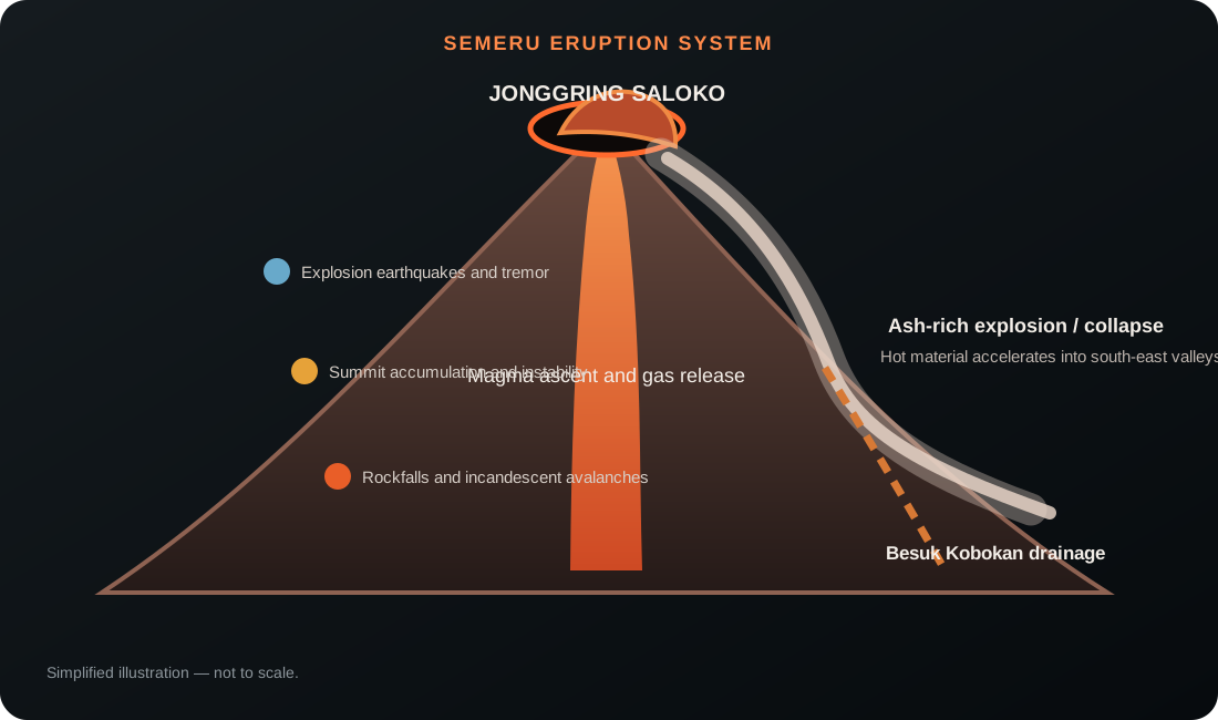
How Semeru erupts
From summit explosion to downstream lahar
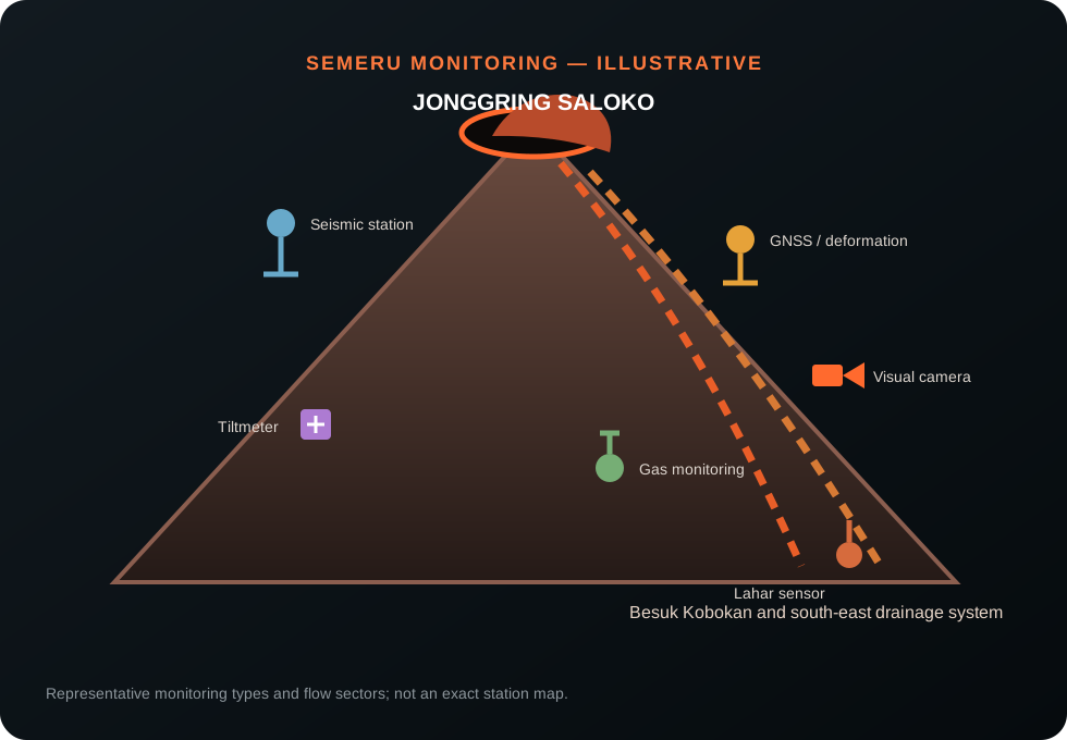
Monitoring
Watching the crater, the valleys and the weather
PVMBG combines summit observations with instruments and river monitoring because Semeru's hazards can continue downstream after the explosive phase has ended.
SeismicityTracks explosions, tremor, rockfall and pyroclastic-flow signals.
Visual camerasFollow plume height, avalanches and weather-obscured periods.
DeformationMeasures changing pressure and movement beneath the summit.
Thermal observationsIdentify hot material and active flow pathways.
Ash reportingSupports public and aviation information.
Rain and lahar sensorsWatch Besuk Kobokan and connected drainage channels.
A volcano through time
Mount Semeru eruption timeline
1818
Early documented eruption
Historical records begin a long account of persistent activity at Java's highest volcano.
1967–present
Long-lived eruptive period
Frequent summit explosions establish Semeru as one of Indonesia's most persistently active volcanoes.
Major disaster4 Dec 2021
Pyroclastic flows devastate south-east communities
A major collapse and pyroclastic-flow episode travelled through the Besuk Kobokan drainage, causing widespread destruction and loss of life.
4 Dec 2022
Major pyroclastic-flow eruption
Activity escalated rapidly, producing long-runout pyroclastic flows and a temporary increase to Level IV Awas.
Recent crisisNov–Dec 2025
Level IV episode and return to Siaga
Repeated pyroclastic flows prompted a temporary Level IV alert before the status was lowered to Level III as the immediate crisis eased.
2026
Persistent Level III activity
Frequent explosions and sector-based pyroclastic-flow and lahar hazards continue under close official monitoring.
What matters most
Semeru's main hazards
≋
Pyroclastic density currents
Fast, hot flows of gas, ash and blocks channelled into the south-east valleys.
☁
Ashfall
Frequent explosions affect health, crops, transport and aviation downwind.
◆
Rockfalls and avalanches
Hot, unstable summit material can descend steep channels without a large explosion.
≈
Lahars
Heavy rain remobilises volcanic deposits through Besuk Kobokan and other rivers.
Volcoholics InsightAt Semeru, the summit eruption is only the beginning of the hazard chain. Valleys and rainfall determine how far destructive material can travel.
Myths and reality
Semeru myths, separated from the science
Frequent small explosions are harmless.
Reality: persistent activity can generate dangerous avalanches, ash and sudden pyroclastic-flow escalation.
The hazard stops at the foot of the cone.
Reality: river channels can carry pyroclastic flows and lahars far downstream.
Level III means one major eruption is imminent.
Reality: Siaga describes high ongoing activity and restrictions, not a countdown.
Clear weather means the volcano is safe.
Reality: summit collapse and channelised flows are controlled by volcanic conditions, not visibility.
Volcoholics Insight
A volcano where the valleys tell the story
Semeru's persistent explosions are only one part of the system. The shape of the summit, steep south-east channels and tropical rainfall determine whether material remains close to the crater or becomes a far-reaching disaster.
Questions answered
Mount Semeru explained
Where can I find Semeru's latest official status?
Use the Volcoholics volcano directory for the latest verified summary, then follow PVMBG and MAGMA Indonesia for authoritative alert levels, exclusion zones and hazard guidance.
Why does Semeru erupt so often?
Its active conduit and persistent magma supply support frequent ash-rich summit explosions.
What is Besuk Kobokan?
A major south-east drainage system that repeatedly channels pyroclastic flows and lahars away from the summit.
Are lahars only dangerous during eruptions?
No. Rain can remobilise old volcanic deposits long after summit activity has reduced.
Why are Semeru's danger zones sector-based?
Steep valleys guide the most dangerous flows in particular directions, especially toward the south-east.
Official science, made readable
Built from the agencies watching Semeru
Today's operational status and exclusion guidance belong to PVMBG and Indonesia's Geological Agency; this profile focuses on Semeru's enduring geology, behaviour, hazards and history. Volcoholics provides context and never replaces official warnings.