Volcano profile · Central Mexico
Popocatépetl
Mexico’s restless giant — a persistently active stratovolcano known for ash emissions, intermittent explosions, lava-dome cycles and far-reaching hazards.
Latest activity and alert level
Check the live status hub
Popocatépetl is persistently active and conditions can change quickly. View the Volcoholics volcano directory for the latest verified official position from CENAPRED and Mexico’s National Civil Protection authorities.
View latest Popocatépetl status →Chapter one
Mexico's restless giant
Popocatépetl rises between Puebla, Morelos and the State of Mexico, forming one of the most recognisable volcanic landmarks in the Americas — and one of the most consequential. With roughly 25 million people living within 100 km of the summit, it is the world's most populated active volcanic system.
At 5,393 metres, it is Mexico's second-highest mountain and a steep composite stratovolcano built through repeated cycles of lava effusion, explosive eruptions, dome growth and dome destruction accumulated over hundreds of thousands of years. Its modern eruptive period resumed in December 1994 after decades of relative quiet and has continued without interruption ever since — producing persistent degassing, periodic ash emissions, repeated explosions and some 30 cycles of lava-dome growth and destruction within the summit crater.
The Nahuatl name Popocatépetl translates as "Smoking Mountain" — a description that has been accurate for much of the last five centuries. Gas-and-steam plumes are a routine feature of the summit visible from Mexico City on clear days. But the volcano's character is not simply picturesque. Ash dispersal routinely affects aviation, water supplies and respiratory health across central Mexico, and the geological record holds evidence of eruptions orders of magnitude larger than anything observed in the modern monitoring era.
Paired in landscape and folklore with the dormant Iztaccíhuatl to the north-east, Popocatépetl is deeply embedded in Mexican national identity. Its persistent activity has made it part of everyday conversation across the country — and its monitoring one of CENAPRED's most demanding continuous operations.
5,393 mSummit elevation
~25 MPeople within 100 km
30+ domesGrowth-destruction cycles since 1994
CENAPREDOfficial monitoring body
Popocatépetl quick facts
- Volcano type
- Composite stratovolcano
- Elevation
- 5,393 metres
- Modern activity
- 1994–present
- Exclusion zone
- 12 km from the crater
- Official authority
- CENAPRED
Activity and behaviour
Persistent explosions, ash emissions and dome growth
Evergreen profile
How Popocatépetl behaves
Popocatépetl commonly produces gas-and-ash emissions, intermittent explosions, incandescent fragments and episodes of lava-dome growth and destruction. Stronger phases can generate ashfall, ballistic hazards and pyroclastic density currents.
Check the latest verified status →Characteristic activityExplosions and ashIntensity can vary substantially over time
Summit processLava-dome cyclesGrowth and destruction can occur repeatedly
Main proximal hazardBallistic fragmentsDanger is greatest close to the crater
Regional hazardAshfallDistribution depends strongly on wind
Official sourceCENAPREDAuthoritative monitoring and public guidance
Chapter two · The visible signal
The Smoking Mountain
Popocatépetl's persistent plume is the visible surface expression of an open, continuously active volcanic system. Water vapour, carbon dioxide, sulphur dioxide and other gases escape from magma and hot material beneath the crater floor — carried upward and dispersed by prevailing winds. Many emissions are weak and contain little or no ash. Others carry fine tephra that can fall on communities tens or hundreds of kilometres downwind, depending on plume height and wind direction.
What makes the plume scientifically significant is what it tells observers about the system below. Changes in gas flux, particularly SO₂ output, reflect changes in magma supply and degassing rates. Increases in ash content indicate fragmentation of new or old material at the vent. A shift from white steam-dominated emissions to grey or brown ash-bearing plumes is one of the primary escalation signals that CENAPRED's monitoring network is calibrated to detect.
The summit crater has hosted repeated lava-dome cycles throughout the modern eruptive period. A viscous dome accumulates on the crater floor, building until an explosion destroys some or all of it — producing ash, incandescent blocks and hot gas. The cycle then restarts. These dome cycles are a defining characteristic of Popocatépetl's activity and a primary driver of the day-to-day variation in its plume character.
Reading the daily report
How to read a Popocatépetl bulletin
CENAPRED reports describe several signals together. A high count is not automatically more dangerous than a low count; the type, energy, ash content and trend all matter.
Chapter three
How Popocatépetl works
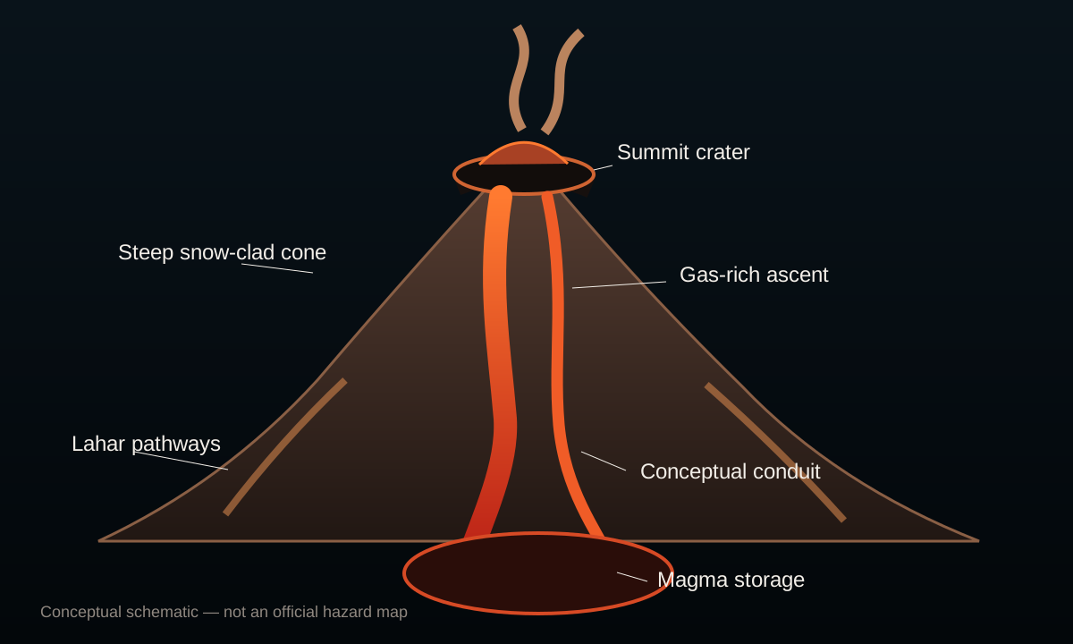
Subduction drives the system
The Cocos oceanic plate descends beneath the North American plate at roughly 6–7 cm per year along Mexico's Pacific coast. As it does so, it releases water and volatiles into the overlying mantle wedge, lowering the melting point and generating magma that rises to feed the Trans-Mexican Volcanic Belt — a chain of volcanoes crossing the country from coast to coast, of which Popocatépetl is one of the most active members.
Gas-rich andesitic magma
Popocatépetl erupts silicic andesite — more viscous and gas-rich than the basaltic systems of Hawaii or Iceland. This composition means that when magma rises, dissolved gases cannot escape easily. Pressure builds until explosive fragmentation occurs, producing ash, pumice and pyroclastic material. The same viscosity that produces explosive behaviour also allows lava domes to form and persist in the crater between explosions.
Dome growth and destruction cycles
Since 1994, the most characteristic feature of Popocatépetl's activity has been the repeated growth and destruction of lava domes within the summit crater. Each cycle involves the slow extrusion of viscous magma, accumulation on the crater floor, and eventual destruction by explosions driven by pressurised gas. Over 30 such cycles have been documented, each producing a pulse of ash, incandescent material and seismic energy.
Water and ice add complexity
Seasonal snow and ice on the upper cone, combined with central Mexico's seasonal rainfall, mean that water interaction is a persistent complication at Popocatépetl. Rain and meltwater mixing with loose ash and volcanic debris on the flanks can mobilise lahars — fast-moving debris flows that travel down river valleys and drainage channels far beyond the eruption zone itself.
Prehistoric scale vs modern activity
The current eruptive period represents moderate activity by Popocatépetl's geological standards. Its prehistoric record includes major Plinian eruptions — such as the "Ochre Pumice" eruption around 800 CE — that generated pyroclastic flows and lahars reaching populated valleys and reshaping the landscape across a far wider area than modern official alert information activity. This geological context is central to understanding why monitoring is taken so seriously.
Chapter four
Living beneath Popocatépetl
Approximately 25 million people live within 100 km of Popocatépetl's summit — making the population exposure at this volcano extraordinary even by global standards. The city of Puebla lies roughly 45 km to the east; Mexico City approximately 70 km to the north-west.
Communities at varying distances face very different hazard profiles. The closest settlements — within 12 km of the crater — must contend with direct explosive hazards: ballistic ejecta, pyroclastic currents in extreme scenarios and rapid lahar onset. At intermediate distances, ashfall is the dominant concern, affecting water supplies, air quality, road networks and agriculture. Lahars are a particular threat along the river valleys draining the southern and eastern flanks, which can channel debris flows far from the volcano even during moderate activity.
At regional scale, ash is the most frequently experienced volcanic impact. Even a thin coating of fine ash can contaminate water catchments, damage vehicle filters, reduce visibility, close airports and cause respiratory problems — particularly for children, the elderly and those with existing conditions. During the 2023 eruption intensification, Mexico City's international airport was temporarily closed by ash dispersal, demonstrating the economic reach of even moderate Popocatépetl activity.
Mexico's volcanic alert system uses a colour-coded traffic light framework that translates monitoring data into public action levels. Popocatépetl's current official alert information (official alert information) allows daily life to continue normally at all but the closest communities, while maintaining preparedness protocols, strict avoidance of the exclusion zone and readiness for escalation.
The volcano is also deeply embedded in Mexican cultural identity. Its profile — paired with the sleeping female outline of Iztaccíhuatl — forms one of Mexico's most iconic landscapes and has been depicted in art, stories and national symbolism for centuries. The Aztec civilisation worshipped Popocatépetl as a deity, and both mountains feature in a famous legend of forbidden love. This cultural familiarity coexists with the ongoing scientific reality: the mountain's plume visible from the capital is a live indicator of an active volcanic system.
Emergency preparedness around Popocatépetl involves CENAPRED, CONAGUA (national water commission), state and municipal civil protection agencies, schools, hospitals and transport infrastructure — all of which have Popocatépetl-specific protocols. Evacuation routes for high-risk communities have been planned and practiced, though the scale of the regional population makes large-scale evacuation a significant logistical challenge.

Chapter five
Watching the smoking mountain around the clock
CENAPRED combines ground instruments, cameras, gas measurements and satellite observations with scientific support from UNAM. The alert phase is based on the combined trend—not on a single earthquake, plume or social-media image.
Seismicity and tremorTrack earthquakes, conduit vibration, explosions and fluid movement.
Visual and thermal camerasFollow plume colour, ash, incandescent ejecta and crater heat.
Gas monitoringSO₂ measurements help describe magma supply and degassing.
DeformationGPS, tilt and satellite radar look for inflation or structural movement.
Ash forecastingWeather data and plume observations support impact and aviation guidance.
Lahar surveillanceRain and flow monitoring support warnings in vulnerable drainage channels.
Chapter six · A long explosive history
Popocatépetl eruption timeline
~23,000 BP
Major prehistoric collapse
Popocatépetl's geological history includes large flank-failure events that produced major debris avalanches. These prehistoric collapses help explain the broad depositional fans visible around the volcano's base and context for why current monitoring includes structural stability assessment.
~800 CE
The Ochre Pumice — one of the largest Holocene eruptions
A major Plinian eruption produced the widespread "Ochre Pumice" deposit — one of the most significant explosive events in Popocatépetl's Holocene record. The eruption generated pyroclastic flows and lahars that travelled far into surrounding valleys and deposited thick tephra across central Mexico. Pre-Columbian communities in the affected areas would have experienced severe disruption. This event is the primary geological benchmark against which modern activity is contextualised.
1519
Activity recorded at European contact
Historical descriptions from the time of the Spanish arrival describe eruptive activity at Popocatépetl. Diego de Ordaz led an expedition to the crater in 1519 — one of the earliest recorded summit climbs of any active volcano in the Americas. Colonial-era accounts document continued activity throughout the 16th and 17th centuries, establishing Popocatépetl as Mexico's most historically documented volcano.
1920–27
Multi-year explosive episode
A significant eruptive period produced ash emissions, explosions and changes to the summit crater over several years. This episode is considered the most significant documented activity before the modern reawakening and established baseline data for the volcano's historical eruptive style.
21 Dec 1994
The modern reawakening
After decades of relative quiet, ash emissions began on 21 December 1994 — initiating the current period of persistent activity that has continued for over three decades. The reawakening triggered urgent installation of expanded monitoring infrastructure, development of the national volcanic alert system and the first modern emergency planning protocols for surrounding communities. Within months, a permanent exclusion zone had been established around the crater.
2000
Major evacuation — first major crisis of the modern era
Escalating dome activity, increased explosion frequency and energetic events prompted the precautionary evacuation of approximately 40,000–50,000 people from higher-risk communities on the flanks in late 2000. The 2000 crisis was the first large-scale test of Mexico's volcanic emergency planning capacity and demonstrated both the effectiveness of CENAPRED's monitoring and the logistical challenges of moving large numbers of people from Popocatépetl's surroundings.
2012–19
Sustained dome cycle period
Multiple episodes of dome growth and explosive destruction characterised this extended period. Ash emissions were frequent, affecting aviation and downwind communities on multiple occasions. Several events required precautionary evacuations of closer communities. The period produced important scientific data on dome cycle dynamics and refine CENAPRED's understanding of escalation indicators.
2023
Intensification — official alert information briefly reached
In May 2023, increased tremor, elevated ash emissions and more frequent explosions caused CENAPRED to temporarily raise the alert to official alert information. Mexico City's Benito Juárez International Airport was closed for several hours due to ash dispersal — one of the most economically significant single impacts of any modern Popocatépetl episode. Wider ash deposition affected multiple Mexican states. The alert was subsequently returned to official alert information as activity moderated.
Current phase2026
official alert information — persistent activity continues
Daily CENAPRED reporting continues to document exhalations, volcanic gas and intermittent ash under official alert information. Activity has fluctuated during 2026, including changes in tremor, long-period events and volcano-tectonic earthquakes, but no alert-level escalation comparable with May 2023 has been declared. The 12 km exclusion zone remains in force.
Chapter seven
The hazards that matter most
☁
Ashfall
The most frequent regional impact. Ash can affect health, water, agriculture, roads, machinery and airport operations far downwind.
✹
Ballistic fragments
Explosions can throw incandescent blocks around the crater and upper flanks. This is why the exclusion zone is non-negotiable.
≋
Pyroclastic currents
Not the normal official alert information behaviour, but a central hazard in larger dome-collapse or explosive scenarios documented by the geological record.
≈
Lahars
Heavy rain and snowmelt can remobilise ash and debris into fast flows through ravines—even when summit activity is not escalating.
Volcoholics InsightPopocatépetl's most common impact is ash, but its most immediate danger near the summit is ballistic ejecta. Distance and wind direction fundamentally change the hazard picture.
Myths and reality
Popocatépetl myths, separated from the science
A white plume means nothing is happening.
Reality: steam-rich emissions are normal at an active open system and still reflect heat and continuous degassing.
Every ash plume means a major eruption.
Reality: small ash-bearing exhalations are common. Height, energy, duration and associated signals determine significance.
official alert information means the volcano is safe to climb.
Reality: access to the crater is prohibited because explosions can throw lethal incandescent fragments without warning.
Mexico City is too far away to be affected.
Reality: fine ash can travel tens or hundreds of kilometres when winds carry the plume towards the capital.
Volcoholics Insight
The smoking mountain never leaves the conversation
"Popocatépetl is powerful not only because it erupts, but because 25 million people read its plume as part of daily life. Its persistent emissions can feel routine — yet its geological history, and the 2023 reminder of what even moderate escalation can do to one of the world's busiest airports, demands that familiarity never be mistaken for safety."
This editorial summary reflects the scientific information above. It does not replace official monitoring, access restrictions or public-safety guidance from CENAPRED, civil protection authorities and Mexican emergency services.
Frequently asked questions
Popocatépetl explained
What is the official monitoring level?
Popocatépetl is currently at official alert information (official alert information) under Mexico's volcanic alert traffic-light system. This level indicates persistent activity with explosions, incandescent fragments and ash — requiring strict exclusion zone compliance and preparedness, but allowing normal daily life at distance. Always check CENAPRED for the current level before any visit to the area.
Is Popocatépetl erupting right now?
It is in a continuous period of activity that has persisted since December 1994. "Erupting" in the Popocatépetl context means ongoing emissions, periodic explosions and dome cycles — not a single dramatic event. This persistent state is monitored continuously by CENAPRED, which publishes daily bulletins describing current behaviour.
What does official alert information mean?
official alert information is the second of three official alert informationphases in Mexico's seven-stage volcanic alert system. It indicates regular low-intensity explosions, some ash-bearing emissions, incandescent material near the crater and possible minor lahars. People must not approach the crater or enter the exclusion zone. Preparedness measures and attention to official guidance are required at all times.
How many people live near Popocatépetl?
Approximately 25 million people live within 100 km of the summit. The cities of Puebla (~3 million, ~45 km east), Tlaxcala, Cuautla and numerous smaller communities sit within the primary ash-impact zone. Mexico City (~22 million people, ~70 km north-west) is affected by ash dispersal during significant eruptions.
Can people climb Popocatépetl?
No. CENAPRED repeatedly and specifically warns that people must not approach the crater because of the risk from explosions and incandescent fragments. The exclusion zone radius varies with activity level. At official alert information, a 12 km exclusion zone around the crater is maintained. Summit climbing is prohibited and has been for most of the modern eruptive period.
Why does ash reach Mexico City?
Fine volcanic ash is carried by winds at altitude and disperses according to wind direction and plume height rather than simply distance. Mexico City sits roughly 70 km north-west of the summit. When upper-level winds blow from the south-east — which happens regularly — ash from significant Popocatépetl explosions reaches the capital. The 2023 intensification caused measurable ash deposition in Mexico City and temporarily closed the international airport.
What are the dome cycles?
Since 1994, Popocatépetl's most characteristic behaviour has been the repeated growth and destruction of lava domes within the summit crater. Viscous andesitic magma extrudes slowly onto the crater floor, building a dome over days to weeks. Pressure from gas accumulating beneath or within the dome eventually causes an explosion that destroys part or all of it — producing ash, incandescent blocks and seismic signals. Over 30 such cycles have been documented since the modern eruptive period began.
What happened in 2023?
In May 2023, Popocatépetl entered an intensified phase with elevated tremor, increased explosion frequency and heavier ash emissions. CENAPRED temporarily raised the alert to official alert information — the highest level the volcano has reached in the modern monitoring era. Mexico City's international airport closed for several hours due to ash on runways, affecting hundreds of flights. Multiple Mexican states received measurable ashfall. The alert returned to official alert information as activity moderated over subsequent weeks.
What is a lahar and when do they occur at Popocatépetl?
Lahars are fast-moving debris flows of water, volcanic ash and boulders that travel down river valleys and drainage channels. At Popocatépetl, lahars are most likely when heavy rainfall or snowmelt remobilises loose ash and volcanic deposits on the flanks — which can happen during or independently of active explosions. Primary lahar corridors drain toward populated valleys on the eastern and southern flanks. CENAPRED monitors river gauge levels in key channels during rainy season.
Who monitors Popocatépetl?
CENAPRED is the lead scientific monitoring and public communication authority. It works in scientific collaboration with the Institute of Geophysics at UNAM and other Mexican research institutions. State and municipal civil protection agencies coordinate emergency response using CENAPRED's data. Daily bulletins are published at cenapred.unam.mx and the official government website.
Could Popocatépetl produce a much larger eruption?
Yes — its geological record is unambiguous on this point. The "Ochre Pumice" Plinian eruption around 800 CE produced pyroclastic flows and lahars that reached far into populated valleys. Similar eruptions in the prehistoric record have reshaped the regional landscape. Nothing in the official monitoring level suggests such an event is imminent, but CENAPRED's monitoring is specifically calibrated to detect the precursors that might signal a transition to significantly larger activity.
Where are official updates published?
CENAPRED publishes daily official bulletins and news updates at gob.mx/cenapred. The National Seismological Service (SSN) provides complementary seismic data. State civil protection websites for Puebla, Morelos and the State of Mexico publish local guidance. All official sources are in Spanish.
About this profile
Official science, made readable
This profile uses CENAPRED bulletins, civil protection information and authoritative scientific literature as its only factual sources. Editorial passages explain the significance of observations while keeping official monitoring data and safety guidance clearly attributed and separate. No news outlet, social media or aggregator site is used as a factual source.
CENAPREDOfficial daily monitoring, alert levels, public-safety guidance and bulletin archive at gob.mx/cenapred.
UNAM Institute of GeophysicsScientific monitoring collaboration, volcanological research and seismic data for Popocatépetl.
Smithsonian GVPGlobal Volcanism Program — geological history, prehistoric eruption records and international catalogue.