Volcano profile · Albay, Philippines
Mayon
One of the world's most symmetrical volcanoes — capable of lava flows, pyroclastic density currents, ash emissions and destructive lahars.
Latest activity and alert level
Check the live status hub
Mayon can change quickly as magma rises, lava accumulates and unstable material collapses from the summit. View the Volcoholics volcano directory for the latest verified official position from PHIVOLCS.
View latest Mayon status →The Philippines' iconic cone
Symmetry shaped by repeated eruption
Mayon rises to about 2,462 metres above Albay and is one of the most recognisable stratovolcanoes on Earth.
Its steep, remarkably symmetrical cone has been built by repeated lava flows, ash, scoria and other volcanic deposits. The same steep geometry that creates Mayon’s famous profile also allows rockfalls, lava-collapse debris and pyroclastic density currents to accelerate rapidly down radial gullies.
Rain adds a second hazard system. Loose volcanic deposits can be remobilised into lahars that move through river channels long after explosive or effusive activity has subsided.
2,462 mSummit elevation
StratovolcanoVolcano type
Permanent Danger Zone6 km radius
PHIVOLCSOfficial monitoring
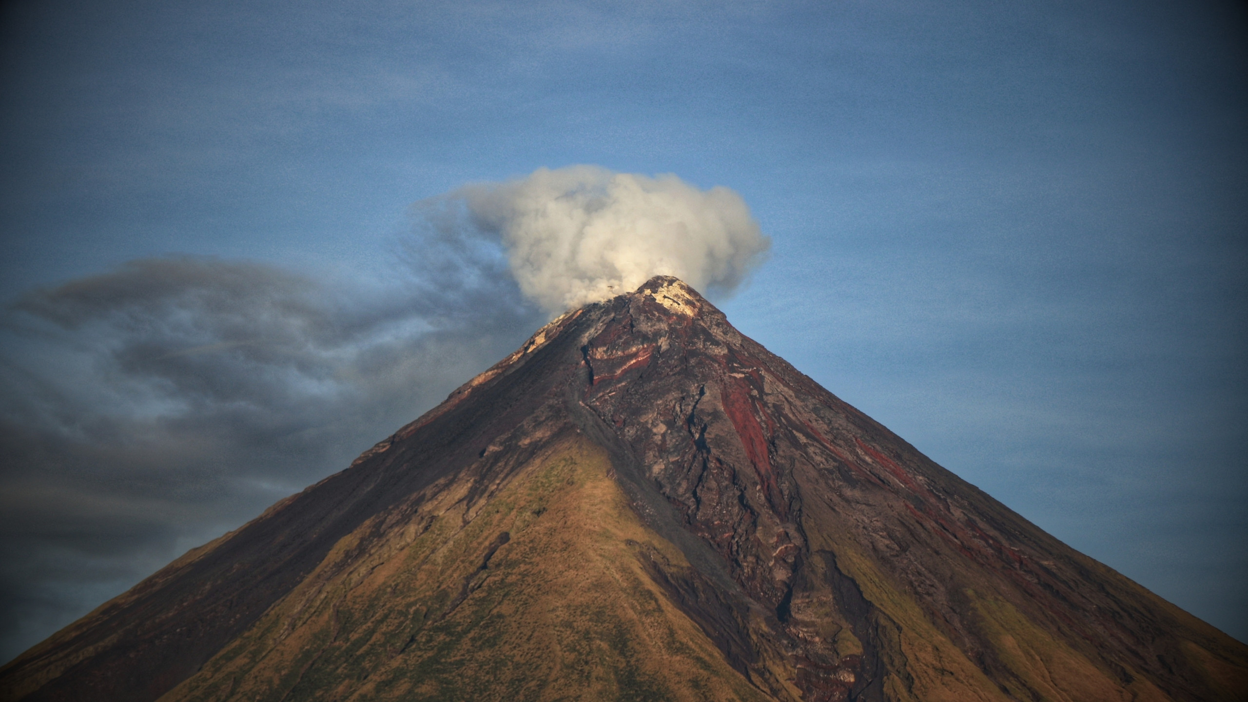
Mayon quick facts
- Volcano type
- Stratovolcano
- Location
- Albay, Bicol Region, Philippines
- Summit elevation
- About 2,462 metres
- Defining feature
- Steep symmetrical cone
- Official agency
- DOST-PHIVOLCS
Activity and behaviour
Lava growth, collapse and valley-focused hazards
Evergreen profile
How Mayon behaves
Mayon can produce lava effusion, lava fountains, ash emissions, rockfalls and pyroclastic density currents. The steep cone and radial gullies strongly control where hot material travels.
Check the latest verified status →Characteristic activityLava effusionFlows can descend established gullies from the summit
Escalation hazardPyroclastic currentsCollapse-fed PDCs can accelerate rapidly downslope
Proximal hazardRockfallsUnstable hot blocks repeatedly move down the cone
Rainfall hazardLaharsLoose deposits are remobilised through river channels
Official sourcePHIVOLCSAuthoritative alerts, bulletins and hazard guidance
A permanent rule around Mayon
The 6-kilometre Permanent Danger Zone
PHIVOLCS has long treated the six-kilometre radius around Mayon as a Permanent Danger Zone because rockfalls, sudden explosions, lava collapse and pyroclastic density currents can occur with limited warning.
Summit and drainage system
A perfect cone cut by dangerous pathways
Mayon’s symmetry hides a highly directional hazard system.
Material leaving the summit does not spread evenly in every direction. Lava, rockfalls and collapse-generated pyroclastic density currents preferentially descend gullies cut into the cone. Rain can later remobilise fresh deposits into lahars farther downstream.
SummitLava, gas, ash and explosive ejecta originate near the crater.
AccumulationHot blocks and lava build on steep upper slopes.
CollapseUnstable material can fail into established gullies.
Channelled flowPDCs and lahars travel through radial drainages.
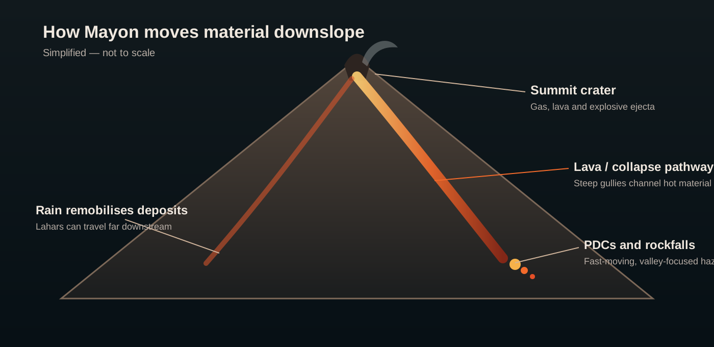
How Mayon erupts
From rising magma to downstream hazard

Monitoring
Watching a steep cone from summit to river channel
PHIVOLCS combines multiple observations because no single signal defines Mayon’s behaviour. Seismicity, deformation, gas, thermal data and direct visual observations are interpreted together.
SeismicityTracks volcanic earthquakes, tremor, rockfalls and flow signals.
Ground deformationElectronic tilt, GPS and other methods track inflation and deflation.
GasSulfur dioxide measurements help assess degassing and magma supply.
Thermal observationsIdentify hot summit material, lava and active flow fronts.
Visual camerasTrack plume height, rockfalls, lava and weather-obscured periods.
River monitoringRainfall and downstream channels matter because of lahar risk.
A volcano through time
Mayon eruption timeline
1616
Early documented eruption
Historical records begin a centuries-long account of repeated activity at Mayon.
Major disaster1814
Destructive eruption overwhelms Cagsawa
One of Mayon’s most famous historical eruptions produced destructive pyroclastic activity and ashfall across surrounding communities.
1897
Powerful explosive eruption
A major eruption produced pyroclastic flows and widespread impacts around the cone.
1993
Sudden pyroclastic flows
An explosive event generated deadly pyroclastic density currents on the volcano’s flanks.
2006
Typhoon-triggered lahars
Heavy rainfall remobilised volcanic deposits into destructive lahars, underlining the importance of post-eruption sediment hazards.
2018
Lava fountaining and lava flows
Renewed magmatic activity produced sustained lava fountains, ash plumes and lava flows.
2023
Effusive eruption and dome-collapse hazards
Lava effusion, rockfalls and collapse-fed pyroclastic density currents again demonstrated Mayon’s steep-slope hazard system.
Modern episode2026
Lava effusion with repeated collapse-fed PDCs
PHIVOLCS documented sustained lava effusion, occasional weak Strombolian activity and repeated pyroclastic density currents within the summit drainage system.
Hazards
Mayon’s danger is both hot and wet
Fast, hot mixtures of gas, ash and rock can descend gullies at destructive speeds.
Fluid-to-blocky lava can advance down established drainage sectors from the summit.
Unstable summit and flank material can move frequently even without large explosions.
Wind controls where ash travels, affecting communities, agriculture and aviation.
Heavy rain can remobilise loose volcanic deposits into dense flows through river valleys.
Sudden explosions can throw large blocks around the summit and upper slopes.
Myths versus reality
The perfect cone is not a predictable cone
In reality, gullies and drainage systems strongly focus lava, PDCs and lahars into particular sectors.
Rockfalls, lava collapse and pyroclastic currents can be serious even during largely effusive activity.
Fresh deposits can be remobilised by heavy rain long after summit activity decreases.
Volcoholics insight
Mayon is a geometry lesson written in hazard
Its famous symmetry is not merely aesthetic. It reflects repeated construction of a steep cone, and that steepness controls how rapidly material can move away from the summit. Understanding Mayon means following the path from crater to gully to river — not simply watching the plume above the peak.
Questions answered
Mayon Volcano explained
Where can I find Mayon’s latest official status?
Use the Volcoholics volcano directory for the latest verified summary, then follow DOST-PHIVOLCS for authoritative alert levels, bulletins, exclusion zones and hazard guidance.
Why is Mayon so symmetrical?
Repeated eruptions have built layers of lava and fragmental material around a central vent, creating an unusually regular steep-sided cone.
What is the Permanent Danger Zone?
PHIVOLCS treats the six-kilometre radius around Mayon as a permanent high-risk zone because rockfalls, explosions, pyroclastic density currents and other hazards can occur with limited warning.
Why are lahars dangerous at Mayon?
Tropical rainfall can remobilise large volumes of loose ash and volcanic debris into fast-moving flows through river channels.
Who monitors Mayon?
DOST-PHIVOLCS operates the official monitoring network and publishes authoritative volcanic bulletins and hazard guidance.
Official science, made readable
Built from the agency watching Mayon
This evergreen profile uses DOST-PHIVOLCS publications and authoritative scientific literature as its factual basis. Geology, eruption style, hazards, monitoring and historical eruptions are presented separately from today’s operational status, which belongs in the Volcoholics volcano directory and official PHIVOLCS bulletins.
DOST-PHIVOLCSOfficial Mayon bulletins, monitoring, hazard maps and public guidance.
PHIVOLCS WOVOdat / LAVAArchived and modern activity reports used for eruption history and monitoring context.
Smithsonian Global Volcanism ProgramLong-term eruption history and geological reference data for Mayon.