Kīlauea is always erupting in the same place.
Reality: activity can shift between Halemaʻumaʻu, the East Rift Zone and the Southwest Rift Zone.
Kīlauea can change rapidly between pauses, lava fountaining and renewed eruptive activity. View the Volcoholics volcano directory for the latest verified official position from USGS Hawaiian Volcano Observatory.
View latest Kīlauea status →One of Earth’s most active shield volcanoes—where Halemaʻumaʻu, vast rift zones and repeated lava-fountain episodes continually reshape Hawaiʻi’s youngest landscape.
Kīlauea is a broad basaltic shield volcano built by repeated eruptions from its summit and two major rift zones. Its low profile hides an enormous volcanic system extending from the summit caldera to the sea.
Halemaʻumaʻu sits within Kaluapele, the summit caldera. For generations it has been one of the most culturally and scientifically significant volcanic places in Hawaiʻi. Modern eruptions have repeatedly transformed the crater through collapse, lava lakes, vents, fountains and rapid resurfacing.
Kīlauea’s basaltic magma is fluid compared with the stickier magma of many explosive stratovolcanoes. That allows spectacular lava fountains and long lava flows—but it does not make the volcano harmless. Gas, tephra, ground cracking, earthquakes and rapidly advancing lava have all affected communities and visitors.
Kīlauea can erupt in repeated fountain cycles separated by pauses, with pressure building, lava and gas being released, and the shallow summit system recharging between eruptive phases.
Kīlauea alternates between summit eruptions, rift-zone intrusions, lava fountaining, fissure eruptions and pauses. The location, duration and style of activity can shift quickly.
Check the latest verified status →
Kīlauea can produce repeated lava-fountain episodes separated by pauses, with pressure, eruption, deflation and recharge shaping the rhythm.
During pauses, the shallow summit system reinflates and glow may remain visible at the vents. As pressure recovers, low-level overflows or dome fountains can appear before the onset of a larger episode.
An episode is one pulse within a longer eruption. The vent system does not shut down permanently when the fountains stop; it begins another pressure-and-recharge cycle.
HVO follows tilt, seismicity, gas, vent glow and lava behaviour to understand where Kīlauea sits within that cycle. The timing and strength of a future episode cannot be read from one signal alone.


Kīlauea does not erupt only at its summit. Two major rift zones carry magma away from the caldera through long bands of fractures and vents.
The East Rift Zone extends towards the island’s eastern coast and hosted the long-lived Puʻuʻōʻō eruption from 1983 to 2018. In 2018, magma drained from the summit and erupted through lower-rift fissures in residential areas, destroying more than 700 structures.
The Southwest Rift Zone has also produced important eruptions and remains part of the active volcanic system. No significant activity is currently reported along either rift zone, but HVO monitors both continuously.
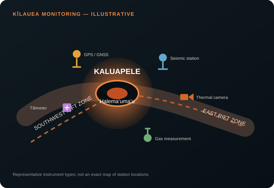
The USGS Hawaiian Volcano Observatory combines dense ground networks with cameras, gas measurements and satellite data. No single instrument predicts an eruption; the strength comes from reading every signal together.
An explosive summit eruption produced pyroclastic surges and remains the deadliest known volcanic event in the present-day United States.
Groundwater interacted with the draining summit system, producing weeks of explosive activity.
Exceptionally high fountains built Puʻupuaʻi and created a deep lava lake in Kīlauea Iki crater.
A 35-year East Rift Zone eruption repeatedly sent lava towards the sea and transformed large areas of the district.
Summit collapse and lower-rift fissures destroyed neighbourhoods and dramatically enlarged Kaluapele.
Several eruptions filled parts of Halemaʻumaʻu with new lava following the 2018 collapse.
The summit eruptive activity began in December 2024 and has produced dozens of discrete lava-fountain episodes separated by pauses, deflation and renewed summit inflation.
Fluid basalt can travel through established channels or new fissures and may threaten roads, infrastructure and communities during rift-zone eruptions.
SO₂ forms vog downwind, affecting air quality across Hawaiʻi even when lava remains confined within the summit.
Lava fountains produce Pele’s hair, Pele’s tears and other fragments that can be carried away from the vents.
Magma movement and flank deformation can generate earthquakes, fractures and sudden changes in access conditions.
Reality: activity can shift between Halemaʻumaʻu, the East Rift Zone and the Southwest Rift Zone.
Reality: Kīlauea has produced major explosive eruptions, including the deadly events of 1790 and the summit explosions of 1924.
Reality: summit fountains may remain confined to the closed crater area, while rift-zone fissures create a very different hazard picture.
Reality: during an episodic eruption, a pause may simply mark the recharge interval before another fountain episode.
“Kīlauea is captivating because its lava makes geology visible in real time. Yet every glowing fountain sits within a much larger system capable of summit collapse, destructive rift eruptions and profound change across the island.”
This editorial summary is based on the scientific information presented above. It does not replace official monitoring or public-safety guidance from USGS HVO, Hawaiʻi County Civil Defense or Hawaiʻi Volcanoes National Park.
HVO combines seismicity, deformation, gas, webcams, thermal imagery, satellite data and field observations to track changes at the summit and along the rift zones.
Use the Volcoholics volcano directory for the latest verified summary, then follow USGS Hawaiian Volcano Observatory for authoritative alert, aviation and eruption information.
USGS HVO reports that renewed summit inflation and vent glow indicate another lava-fountain episode is likely, though timing remains uncertain.
The recent eruptive activity is confined to vents inside Halemaʻumaʻu within Kaluapele at Kīlauea’s summit.
It is the pit crater and active vent area within Kīlauea’s summit caldera.
The shallow summit magma system repeatedly pressurises, erupts and deflates before beginning another recharge cycle.
The USGS Hawaiian Volcano Observatory operates the scientific monitoring networks.
There is no active fountaining during pauses. Access and visibility depend on Hawaiʻi Volcanoes National Park rules, weather and official closures.
Vog is volcanic air pollution formed when sulphur dioxide reacts in the atmosphere.
Yes. Its East and Southwest Rift Zones have produced many eruptions, including the destructive 2018 lower-rift eruption.
The north vent reached about 500 feet, or 150 metres, above ground level.
Use the USGS HVO Kīlauea updates, webcams and volcano-notification pages.
Volcoholics Atlas chapters use official observatory publications, civil-protection information and authoritative eruption records. Editorial passages explain why the observations matter while keeping official monitoring and safety guidance clearly separate.