Latest activity and alert level
Check the live status hub
Activity across the Reykjanes Peninsula can change quickly. View the Volcoholics volcano directory for the latest verified official position from the Icelandic Meteorological Office.
View latest Iceland status →North Atlantic · A country built by fire and ice
Iceland
One of Earth's most volcanically active countries — where a mid-ocean ridge rises above sea level, a mantle plume pushes from below, and fire has shaped the land since the first settlers arrived.
Scroll to explore the fires ↓
Chapter one
A country built by fire
Iceland is one of the few places on Earth where an active mid-ocean ridge rises above sea level — placing an entire country directly across the boundary between the North American and Eurasian plates as they pull apart.
The result is a landscape unlike anywhere else. Fissure swarms, shield volcanoes, stratovolcanoes, calderas, subglacial systems and geothermal fields crowd a land area smaller than the United Kingdom. The island has 33 officially catalogued active volcanic systems, and eruptions occur somewhere in Iceland on average every four to five years.
But Iceland's volcanism is not simply a product of plate spreading. A mantle plume — a column of anomalously hot material rising from deep in the Earth — lies beneath central Iceland. The combination of ridge spreading and hotspot activity produces far more magma than a typical mid-ocean ridge, which is why Iceland grew large enough to emerge from the ocean at all. The hotspot has remained broadly stationary while the North American plate moves westward, which is why the oldest Icelandic rocks are found at the eastern and western margins, with the youngest landscape concentrated along the active rift zones in the centre.
Eruptions here vary enormously in style. Some produce gentle lava flows from long fissures, advancing slowly across flat lowlands. Others explode violently beneath glaciers, generating ash plumes that can reach commercial flight altitudes and sudden catastrophic meltwater floods. The same country that hosts photogenic lava fields accessible to hikers also contains subglacial volcanoes capable of disrupting hemispheric aviation and producing flood pulses measured in cubic kilometres.
33Active volcanic systems
~4–5 yrsAverage interval between eruptions
Rift & plumeDual volcanic driver
IMOOfficial monitoring authority
Iceland quick facts
- Active systems
- 33 officially catalogued
- Volcanic drivers
- Mid-Atlantic Ridge + mantle plume
- Current focus
- Svartsengi–Sundhnúkur
- Last eruption ended
- 5 August 2025
- Official authority
- Icelandic Meteorological Office
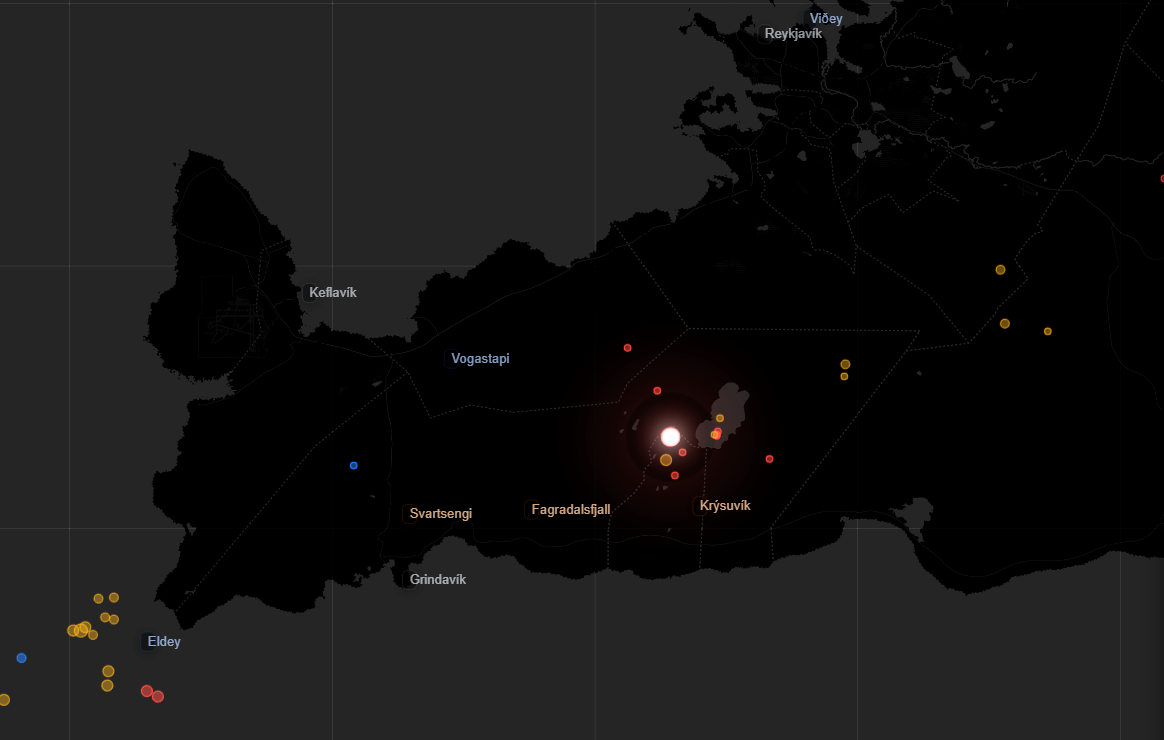
Activity and behaviour · Reykjanes Peninsula
A peninsula reawakened by rifting and magma intrusion
Evergreen profile
How Reykjanes behaves
The peninsula contains several volcanic systems capable of earthquake swarms, ground deformation, dyke intrusions and basaltic fissure eruptions. Activity often develops in episodes separated by quieter intervals.
Check the latest verified status →Characteristic styleBasaltic fissure eruptionsLow-viscosity lava from opening cracks
Main tectonic processRiftingPlate separation creates space for magma
Magma movementDyke intrusionMagma can travel laterally before eruption
MonitoringSeismic and deformationGNSS, InSAR and earthquake networks
Official sourceIMOAuthoritative science and hazard information
▶
Iceland live monitoring
Follow Iceland's earthquakes, seismic signals, live volcano cameras and GPS deformation data through the Volcoholics 24/7 stream. IMO and Civil Protection remain the official authorities for scientific and public-safety decisions.
Watch Iceland Live ↗What happens before an eruption?
From slow inflation to a fissure opening
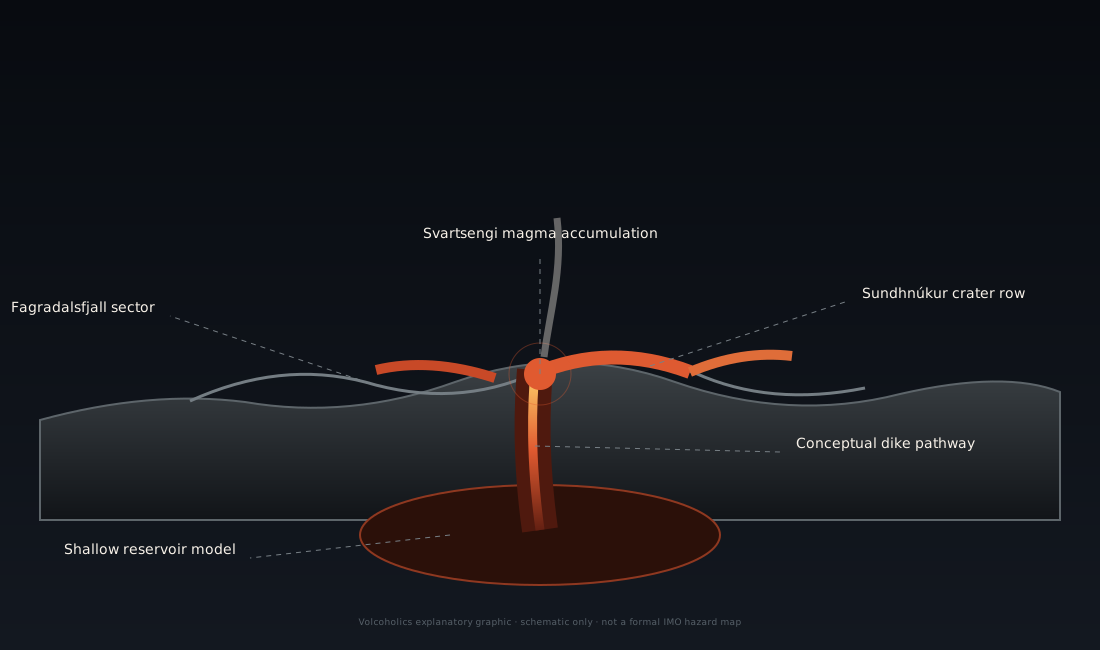
Reykjanes eruptions are often preceded by months of magma accumulation, followed by a much faster final sequence. The slow phase tells scientists the system is recharging; the rapid phase reveals where magma is moving.
Not a countdown:Uplift shows magma accumulation, but it does not provide an exact eruption date. Scientists assess deformation, seismicity and modelling together.
Chapter two
Rift, hotspot and rising magma
A divergent plate boundary above sea level
The Mid-Atlantic Ridge — where the North American and Eurasian plates pull apart at roughly 2 cm per year — passes directly through Iceland. This makes Iceland unique: the only place where this divergent boundary is exposed on land, allowing geologists to study mid-ocean ridge processes in detail. As the plates separate, the gap is continuously filled by rising magma, creating new crust.
The Iceland mantle plume
Beneath central Iceland, a column of anomalously hot mantle material rises from depth — a so-called hotspot or mantle plume. This additional heat source strengthens and sustains Iceland's volcanism well beyond what rift spreading alone would produce. The combination of ridge and plume is why Iceland exists at all as a subaerial landmass rather than a submerged ridge.
Fissure swarms and lateral dikes
Icelandic eruptions frequently begin not at a summit but from long fissures — cracks in the crust through which magma erupts across several kilometres simultaneously. Magma can also travel laterally through dikes for tens of kilometres from its storage area before reaching the surface. This is why eruptions in the Svartsengi system have occurred along the Sundhnúkur crater row rather than directly above the magma reservoir.
Ice changes everything
Much of Iceland's most dangerous volcanic activity involves the interaction of magma with glacial ice. When magma erupts subglacially, rapid steam generation fragments the lava explosively, producing fine ash capable of reaching aircraft cruising altitudes. Simultaneously, meltwater accumulates beneath the glacier until it is released catastrophically as a jökulhlaup — a glacial outburst flood capable of destroying bridges, roads and coastal lowlands within hours.
Chapter three · The modern fires
Reykjanes since 2021
The Reykjanes Peninsula entered a new eruptive era in March 2021 — the first eruptions on the peninsula in approximately 800 years, following a long dormant interval consistent with the geological pattern of centuries-long activity cycles separated by similar periods of quiet.
Activity began at Fagradalsfjall with three largely remote, tourist-accessible eruptions between 2021 and 2023. Then, in November 2023, the character of the unrest changed dramatically. A dike intrusion propagated southward beneath the town of Grindavík, cracking roads and buildings and forcing evacuation of its 3,800 residents with little warning. The first Sundhnúkur eruption followed on 18 December 2023, beginning a rapid-fire sequence of nine fissure eruptions over the following twenty months.
These eruptions have repeatedly threatened Grindavík, the Svartsengi geothermal power plant, and the Blue Lagoon. Defensive earthwork barriers were constructed around the town perimeter. Lava has entered defensive berms and reached the coast on multiple occasions. One person is presumed to have died as a result of ground cracking. The series has transformed the landscape of the western Reykjanes Peninsula and fundamentally changed life in Grindavík.
Mar 2021
Fagradalsfjall — the first eruption in 800 years
A fissure erupted in the remote Geldingadalir valley south of Fagradalsfjall, ending centuries of quiet on the peninsula. Accessible by foot, it became one of the most-visited volcanic eruptions in Icelandic history — an estimated 700,000 people walked to within viewing distance during its six-month run.
Aug 2022
Meradalir
The Fagradalsfjall system reactivated in the neighbouring Meradalir valley. A three-week eruption produced around 12 million cubic metres of lava before stopping. Remote and non-threatening to infrastructure, but larger and more vigorous than 2021.
Jul 2023
Litli-Hrútur
A third Fagradalsfjall eruption — more intense than its predecessors, with higher effusion rates and significant SO₂ emissions. Scientists noted the increasing vigour suggested the system was maturing. Lasted approximately a month.
Nov 2023
Grindavík crisis — the ground cracks
An intense seismic swarm and dike intrusion propagated toward Grindavík, causing ground cracking across the town. Residents were evacuated at short notice. This was the event that shifted the hazard from remote landscape to populated community — a defining moment in the crisis.
Dec 2023
First Sundhnúkur eruption — the series begins
At 22:17 UTC on 18 December 2023, a fissure erupted along the Sundhnúkur crater row north of Grindavík. It was the first in a series of nine eruptions over the following twenty months, in a system fed by the shallow Svartsengi magma reservoir at 4–5 km depth.
2024
Six further eruptions
Eruptions on 14 January, 8 February, 16 March, 29 May, 22 August and 20 November 2024 — varying in duration from hours to weeks, each preceded by rapid GPS deflation at Svartsengi as magma migrated toward the fissure. Lava repeatedly threatened the town perimeter and infrastructure.
2025
Eighth and ninth eruptions — then a long pause
Two further eruptions occurred in 2025. The ninth ended on 5 August, after which uplift resumed beneath Svartsengi and the surface entered its longest quiet interval of the Sundhnúkur sequence so far.
Current phase2025–2026
Steady magma accumulation beneath Svartsengi
Ground uplift has continued through 2026 while seismicity has remained comparatively low. IMO's 3 July update kept continued accumulation, a future dike intrusion and a possible eruption as the possible future scenario, while stressing that the timing cannot be forecast precisely.
Chapter four
Iceland's major volcanic systems
Iceland's 33 active volcanic systems vary enormously in character — from the fissure-dominated systems currently erupting on Reykjanes, to vast subglacial calderas capable of disrupting hemispheric aviation and flooding coastal plains. Each has its own eruption history, hazard profile and monitoring requirements.
⌁
Reykjanes Peninsula
Four fissure swarm systems — Reykjanes–Eldvörp–Svartsengi, Krýsuvík, Brennisteinsfjöll and Hengill — currently most active at Svartsengi. Nine eruptions since December 2023. Cycle expected to continue for decades based on historical precedent.
▲
Grímsvötn
Iceland's most frequently erupting system, buried beneath Vatnajökull. Erupts on average every 5–10 years. Associated with recurring subglacial lake drainage and jökulhlaups. The 2011 eruption briefly disrupted European aviation.
◉
Bárðarbunga
A vast subglacial caldera system beneath Vatnajökull, capable of producing Iceland's largest eruptions. The 2014–15 Holuhraun event — fed by a 45 km dike — was the largest Icelandic lava eruption in over 200 years, producing massive SO₂ pollution across Europe.
△
Katla
A large caldera beneath Mýrdalsjökull, historically one of Iceland's most dangerous volcanoes. The last confirmed major eruption was 1918. Its jökulhlaup potential is severe — the 1918 flood had a peak discharge estimated at 300,000 m³/s. Considered significantly overdue.
✹
Hekla
A highly active ridge volcano on the south flank of the rift zone, known for rapid escalation — eruptions have begun with less than an hour of seismic precursors. Combines explosive opening phases with prolonged effusive lava production. Last erupted in 2000.
◎
Askja
A remote caldera complex in the central highlands, famous for the violent 1875 Plinian eruption whose tephra forced mass emigration from north-east Iceland. Experiencing significant unrest and uplift since 2021 — closely monitored by IMO.
⌁
Krafla
A northern caldera and fissure swarm system whose "Krafla Fires" of 1975–1984 produced 21 episodes of rifting and nine eruptions over nine years — a sustained volcano-tectonic event that transformed understanding of Icelandic rifting.
☁
Eyjafjallajökull
A glacier-covered stratovolcano whose April 2010 eruption became globally infamous after fine silicic ash from magma–ice interaction entered European flight corridors, grounding thousands of flights for weeks and causing billions in economic losses.
▲
Öræfajökull
Iceland's highest volcano at 2,110 m, capped by a large glacier. Responsible for the devastating 1362 eruption that destroyed the Litlahérað district and produced Iceland's largest known jökulhlaup. Showing elevated seismicity in recent years.
Chapter five · A land shaped by eruptions
Iceland eruption timeline
c. 934
Eldgjá — one of the largest eruptions of the Common Era
The Eldgjá fissure eruption produced approximately 18–20 km³ of lava across one of the longest volcanic fissures on Earth. Sulphur-rich gas caused significant environmental and climate effects across the Northern Hemisphere. Ice core records from Greenland and Alpine glaciers preserve evidence of the aerosol signal. The eruption likely caused famine and population hardship in Iceland and across Europe and Asia.
~950–1240
Previous Reykjanes Fires
A prolonged period of repeated fissure eruptions across the Reykjanes Peninsula — the direct predecessor to the current active cycle. Multiple systems erupted over roughly three centuries. The last events in this period ended around 1240 CE, initiating the ~780-year dormancy that preceded the 2021 awakening.
1362
Öræfajökull — Iceland's most destructive eruption
A violent explosive eruption from Öræfajökull produced the largest known jökulhlaup in Icelandic history. The flood completely destroyed the Litlahérað district — one of Iceland's most prosperous farming areas — killing most inhabitants and their livestock. The area remained largely uninhabited for decades afterward.
1783–1784
Laki — a global disaster
The Lakagígar (Laki) fissure eruption released approximately 14 km³ of lava and an estimated 120 million tonnes of SO₂ over eight months. The resulting "Laki haze" poisoned Icelandic pastures, killing roughly 80% of sheep and 50% of cattle. About 25% of Iceland's human population died in the subsequent famine. The aerosol cloud influenced Northern Hemisphere climate for years and has been linked to drought and famine as far as Egypt and India.
1918
Katla — the last great jökulhlaup
A major subglacial eruption beneath Mýrdalsjökull generated an immense glacial outburst flood across Mýrdalssandur. Peak discharge is estimated at 200,000–300,000 m³/s — greater than the combined flow of the Amazon and Mississippi rivers. The flood extended the southern coastline by several kilometres with deposited sediment.
1963–1967
Surtsey — a new island born
A submarine eruption south of the Westman Islands built a completely new island above the Atlantic Ocean over three and a half years. Surtsey became one of the most scientifically valuable natural laboratories in the world — a pristine volcanic surface colonised from scratch by biological life. It is now a UNESCO World Heritage Site.
2010
Eyjafjallajökull — aviation brought to a halt
An eruption beneath Eyjafjallajökull's glacier produced sustained fine silicic ash through magma–ice interaction. The ash cloud entered the main European aviation corridors and led to the closure of airspace across much of Europe for six days, with further periodic disruptions over several weeks — affecting approximately 10 million passengers and costing the aviation industry an estimated €1.3 billion.
2014–2015
Holuhraun — Iceland's largest modern lava eruption
A 45-kilometre dike propagated laterally from Bárðarbunga's caldera, breaking the surface beyond the glacier margin and feeding an eruption that produced approximately 1.4 km³ of lava over six months — Iceland's largest lava eruption since Laki. SO₂ emissions repeatedly exceeded health thresholds across Iceland and were detectable across Europe.
Chapter six
Iceland's main volcanic hazards
↘
Lava flows and ground rupture
Reykjanes fissures can open with limited warning, cut roads, crack towns and threaten geothermal infrastructure. Lava may move quickly across low ground during the opening hours.
☁
Ash and aviation
Explosive and subglacial eruptions can inject fine ash into North Atlantic flight routes. The risk depends strongly on magma composition, ice interaction, plume height and wind.
≈
Jökulhlaups
Heat beneath glaciers can release sudden meltwater floods capable of destroying bridges, roads and coastal plains far from the eruption itself.
◇
Volcanic gas
SO₂ and volcanic haze can affect air quality well beyond an active fissure. Wind forecasts and official gas-dispersion guidance are essential during eruptions.
Volcoholics InsightIceland's hazard picture changes with the setting. Reykjanes is dominated by fissures, lava, gas and ground rupture; glacier-covered systems add explosive ash and catastrophic meltwater floods.

Chapter seven
One country, thirty-three systems, one monitoring network
IMO combines national earthquake detection with deformation, gas, satellite, camera, weather and hydrological data. The network must be able to follow a shallow dike beneath a town and a remote subglacial volcano beneath kilometres of ice.
SeisComP earthquake networkReal-time earthquake detection and analysis across the whole country.
GNSS and tiltTrack inflation, deflation and rapid displacement during dike intrusions.
InSAR satellitesMap broad deformation patterns, including remote and ice-covered systems.
Gas and air qualityMeasure SO₂ and support public-health and dispersion guidance.
Cameras and thermal dataFollow fissures, lava fronts, plume behaviour and surface heat.
Hydrology and weatherDetect glacial meltwater changes and drive ash and gas forecasts.
Myths and reality
Iceland volcano myths, separated from the science
Every earthquake swarm means an eruption.
Reality: Iceland has frequent tectonic and geothermal swarms. Magma movement is assessed using location, depth, deformation and other signals together.
Uplift gives an eruption date.
Reality: inflation shows pressure and accumulation, but the threshold for a dike intrusion changes from one episode to the next.
All Icelandic eruptions behave like Reykjanes.
Reality: Iceland also has explosive central volcanoes, glacier-covered calderas and systems capable of ash-rich eruptions and jökulhlaups.
An eruption in Iceland closes European airspace.
Reality: most basaltic fissure eruptions produce little ash. Aviation disruption depends on explosive fragmentation, plume height, wind and ash concentration.
Volcoholics Insight
A country where the Earth never feels far beneath your feet
"Iceland is not one volcano — it is an entire living volcanic laboratory. From fissures currently erupting on the Reykjanes Peninsula to glacier-covered giants capable of global climate effects, nowhere else shows so clearly how magma, tectonics, ice and weather interact. Reykjanes commands today's attention, but the full depth of Iceland's volcanic character lies in the extraordinary variety of what rumbles beneath the whole country."
This editorial summary reflects the scientific information above. It does not replace official monitoring, access restrictions or public-safety guidance from the Icelandic Meteorological Office, Almannavarnir and local authorities.
Frequently asked questions
Iceland volcanoes explained
Is Iceland erupting right now?
No active eruption is described in the latest official IMO update. Slow magma accumulation and uplift continue beneath Svartsengi, with the most likely eventual scenario being a further dike intrusion and possible eruption along the Sundhnúkur crater row. Timing cannot be forecast precisely. Always check IMO directly for current status.
Is it safe to visit Iceland?
Yes — Iceland remains safe to visit. Reykjanes eruptions are localised events that have not threatened Reykjavík or Keflavík Airport. The main visitor impacts are potential Blue Lagoon closures and road closures near the active zone. Always check Almannavarnir and IMO for current access conditions near the Reykjanes Peninsula before travelling to that area.
Why does Iceland have so many volcanoes?
Iceland sits on the Mid-Atlantic Ridge — where the North American and Eurasian plates are actively pulling apart — and simultaneously above a mantle plume that provides additional heat and magma supply. This combination is unique on land anywhere on Earth, producing far more volcanic activity than rift spreading alone would generate.
Which Icelandic volcano erupts most often?
Grímsvötn, beneath Vatnajökull, has the highest eruption frequency in Iceland's historical and geological record — erupting roughly every 5–10 years on average, though many events are only detected through seismic and hydrological signals rather than visible surface activity.
What is a jökulhlaup?
A sudden glacial outburst flood caused when volcanic or geothermal heat melts ice beneath a glacier. Meltwater accumulates in a subglacial lake until it breaches its ice dam and is released catastrophically. Icelandic jökulhlaups have produced discharge rates exceeding all the world's rivers combined and can travel to the coast in hours.
Why was Eyjafjallajökull so disruptive?
The 2010 eruption occurred beneath the glacier, which caused rapid steam generation and very fine fragmentation of the silicic magma into ash particles small enough to remain airborne for days. These particles entered the main European aviation corridors, and regulators grounded aircraft due to the risk of engine damage from ash ingestion — affecting approximately 10 million passengers.
Why is Reykjanes suddenly active after 800 years?
The geological record shows this is normal behaviour — Reykjanes experiences prolonged active periods lasting hundreds of years, separated by similar periods of dormancy. The current reactivation beginning in 2021 is consistent with the long-cycle pattern. Scientists expect the current active phase to continue for decades, with further eruptions across multiple peninsula systems likely over that timeframe.
What happened to Grindavík?
The town of 3,800 people was evacuated in November 2023 when a dike intrusion cracked roads and buildings beneath it. Subsequent eruptions have repeatedly threatened its perimeter. Defensive earthwork barriers have been constructed around the town. The population situation remains difficult — some residents have returned between eruptions while others have relocated permanently.
Is Katla overdue for an eruption?
Katla has historically erupted roughly every 40–80 years. The last confirmed major eruption was 1918, making the current interval unusually long. IMO monitors Katla continuously for signs of escalating unrest. It is considered one of Iceland's highest-priority volcanic hazard concerns due to its jökulhlaup potential and proximity to populated areas.
Who monitors Iceland's volcanoes?
The Icelandic Meteorological Office (IMO / Veðurstofa Íslands) is the official monitoring and hazard assessment authority. Almannavarnir (Icelandic Civil Protection and Emergency Management) issues access and evacuation decisions. The University of Iceland's Institute of Earth Sciences conducts research and contributes to monitoring. All publish information in English at their official websites.
What was the Holuhraun eruption?
The 2014–15 Holuhraun eruption was Iceland's largest since Laki in 1783. A 45 km dike propagated laterally from Bárðarbunga's caldera system, erupting beyond the glacier margin and producing approximately 1.4 km³ of lava over six months. SO₂ emissions repeatedly exceeded health thresholds across Iceland and were measurably detected over mainland Europe.
Where should I check for official updates?
The Icelandic Meteorological Office publishes real-time seismic data, volcanic hazard assessments and news updates at en.vedur.is. Almannavarnir publishes access and evacuation decisions at almannavarnir.is. Both publish in English. These are the only authoritative sources for Iceland's current volcanic status.
About this profile
Official science, made readable
This profile uses Icelandic Meteorological Office publications, Almannavarnir guidance and authoritative scientific literature as its only factual sources. Editorial passages explain the significance of observations while keeping official data and safety guidance clearly attributed. No news outlet, social media or aggregator site is used as a factual source.
Icelandic Meteorological OfficeOfficial real-time monitoring, hazard assessments, seismic data and scientific news updates — en.vedur.is.
Almannavarnir — Civil ProtectionOfficial access decisions, evacuation guidance and public safety information — almannavarnir.is.
Catalogue of Icelandic VolcanoesOfficial profiles of Iceland's 33 active volcanic systems, maintained by IMO, University of Iceland and Civil Protection.
Keep exploring