Volcano profile · North Halmahera, Indonesia
Ibu
A broad, truncated stratovolcano with deeply nested summit craters — known for frequent ash explosions, crater-floor lava and long-lived eruptive activity.
Latest activity and alert levelCheck the live status hub
Ibu’s explosion frequency and ash output can change quickly. View the Volcoholics volcano directory for the latest verified official position from PVMBG / MAGMA Indonesia.
View latest Ibu status →A flat-topped volcano with a deep interior
The summit is defined by craters within craters
Ibu rises to about 1,357 metres on the north-west coast of Halmahera and is a composite stratovolcano with a distinctly truncated summit.
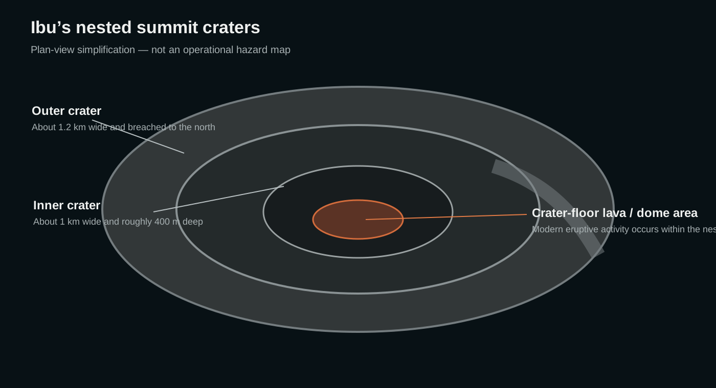
Its outer summit crater is roughly 1.2 kilometres wide and breached to the north. Inside it lies an inner crater about one kilometre wide and roughly 400 metres deep, where modern eruptive activity is concentrated.
That nested geometry gives Ibu a very different personality from a classic pointed cone. Ash explosions, lava accumulation and rock avalanches take place within a deep crater system before material escapes into the atmosphere or moves down the flanks.
1,357 mSummit elevation
StratovolcanoVolcano type
Nested cratersDefining feature
PVMBGOfficial monitoring

Ibu quick facts
- Volcano type
- Composite stratovolcano
- Location
- North Halmahera, Indonesia
- Inner crater
- ~1 km wide / ~400 m deep
- Outer crater
- ~1.2 km wide
- Official agency
- PVMBG / MAGMA
Activity and behaviour
Persistent ash explosions above a hot crater floor
Evergreen profile
How Ibu behaves
Ibu commonly produces repeated ash-rich explosions, white-to-grey emissions, thermal anomalies and occasional rock avalanches. Lava or dome-like material can accumulate within the inner crater.
Check the latest verified status →Characteristic activityAsh explosionsFrequent explosive events from the summit
Crater activityHot lava / domeIncandescent material may accumulate inside the inner crater
Common signalThermal anomalySatellite heat signatures often reveal hot crater material
Secondary processRock avalanchesUnstable crater material can move down the flanks
Official sourcePVMBG / MAGMAAuthoritative monitoring and hazard guidance
A deep crater does not contain every hazard
The summit traps lava — but ash escapes easily
Ibu’s inner crater can contain lava and collapse debris, but explosive ash columns rise well above the summit and can drift far downwind. Ballistic fragments, rock avalanches and volcanic gas remain important near the crater.
Summit architecture
A kilometre-wide crater inside a larger broken summit
Ibu’s nested craters are central to how the volcano looks and behaves.
The outer crater is breached on the north, forming a steep-walled valley. Inside it, the deeper inner crater has hosted small crater lakes in the past and now contains the focus of modern eruptive activity.
Outer craterAbout 1.2 km wide and breached to the north.
Inner craterAbout 1 km wide and roughly 400 m deep.
Crater-floor activityLava, dome growth and explosive vents can occupy the inner floor.
Flank featuresPyroclastic cones and maars occur around the broader edifice.
How Ibu erupts
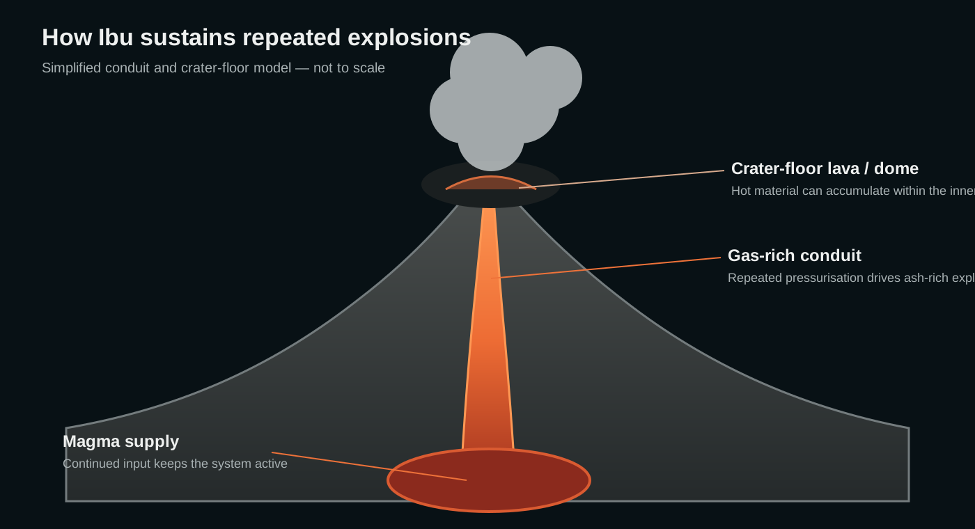
A deep crater system repeatedly vents gas and ash
Magma and gas rise through the conduit into the inner crater, where lava can accumulate and degas. Pressure released through the vent drives repeated ash-rich explosions, while unstable hot material can collapse into avalanches.
The modern eruption is persistent rather than a single short event, so the important question is often not whether Ibu is active, but how its intensity is changing.
Monitoring
Counting explosions while watching heat and ash
PVMBG combines seismic records, direct observations and remote sensing to track Ibu’s persistent activity. Explosion counts, plume heights and thermal observations help distinguish routine activity from escalation.
A volcano through time
Ibu eruption timeline
1911
Short explosive-effusive eruption
A brief documented eruption produced explosions and effusive activity from the summit area.
Modern reawakening1998–1999
Ash, lava and dome growth return
After decades without documented eruption, explosive ash emissions resumed and lava or dome growth developed inside the summit crater.
2001–2004
Intermittent crater activity
Reports suggested continued or renewed hot material and possible dome growth within the crater.
Persistent eruption2008–present
Frequent ash explosions become the norm
The current eruptive period began in April 2008 and has been dominated by intermittent-to-daily ash plumes, explosions and thermal anomalies.
2024
Episodes of stronger explosive activity
The long-running eruption intensified at times, demonstrating that persistent background activity can still escalate into larger ash-producing events.
Hazards
Ibu’s main hazards
Frequent ash can affect breathing, crops, water, machinery and visibility.
Explosive blocks and bombs threaten the summit and proximal slopes.
Unstable hot crater material can collapse and move downslope.
Gas emissions are part of the persistent eruptive system.
Ash plumes can affect flight routes over Halmahera and nearby seas.
Heavy tropical rainfall can wash loose ash and debris into drainage channels.
Myths versus reality
A deep crater does not make Ibu contained
Lava may remain within the crater, but ash, gas and ballistic material can escape above and beyond it.
Explosion size, ash height and seismic intensity can change significantly.
Long-running eruptions can still produce periods of stronger explosive behaviour.
Volcoholics insight
Ibu hides much of its eruption inside the mountain — until the ash escapes
The nested crater system can contain lava, hot debris and repeated vent activity out of sight from surrounding lowlands. But ash columns erase that sense of containment instantly, carrying the eruption from a deep summit crater into the wider atmosphere.
Questions answered
Ibu explained
Where can I find Ibu’s latest official status?
Use the Volcoholics volcano directory for the latest verified summary, then follow PVMBG / MAGMA Indonesia for authoritative alert levels, bulletins and exclusion guidance.
What type of volcano is Ibu?
Ibu is a composite stratovolcano with pyroclastic cones, maars and a broad truncated summit.
How large are Ibu’s summit craters?
The outer crater is about 1.2 km wide, while the inner crater is about 1 km wide and roughly 400 m deep.
When did Ibu’s current eruption begin?
The present long-running eruptive period began in April 2008.
Who monitors Ibu?
Indonesia’s PVMBG provides official monitoring and public hazard information through MAGMA Indonesia.
Official science, made readable
Built from the agencies watching Ibu
This evergreen profile uses PVMBG / MAGMA Indonesia reporting and Smithsonian Global Volcanism Program records as its factual basis. Geology, eruption style, hazards, monitoring and historical eruptions are separated from today’s operational status.
PVMBG / MAGMA IndonesiaOfficial Indonesian volcano monitoring, bulletins and hazard guidance.
Smithsonian Global Volcanism ProgramLong-term eruption chronology, summit morphology and geological reference information for Ibu.