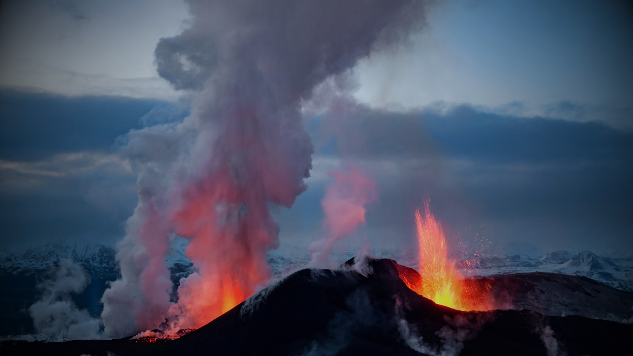
The eruption that began on 13 February 2026 ended on 25 March at approximately 4:30 PM local time, confirmed by OVPF after volcanic tremor dropped in two successive steps — at 9:50 AM and again at 1:45 PM local time — before returning to background noise levels around 3:00 PM. The eruption lasted 41 days, roughly twice the average duration for Piton de la Fournaise, and erupted an estimated 20–25 million cubic metres of lava.
Critically, scientists are not ruling out a resumption. Deep-source deflation is continuing, lava tube drainage will remain active for days to weeks, and the lava platform built at the ocean entry point is highly unstable due to partially emptied tubes beneath its surface. Road repair work on the severed RN2 is expected to begin within 15–30 days. The new lava delta covers approximately 8 hectares — equivalent to 11 football pitches — added permanently to Réunion's eastern coastline.
Episode 43 of the ongoing Kīlauea eruption occurred on 10 March, producing lava fountains estimated at 540 metres — the highest of the entire eruption series that began in December 2024. Over its 9-hour duration, it erupted an estimated 12 million cubic metres of lava, bringing the total across all episodes since December 2024 to approximately 250 million cubic metres. Tephra fell across communities up to 80 km away, Highway 11 was temporarily closed, and ash reached Hilo, Keaʻau, and the Hamakua coast. USGS scientists conducted a monitoring overflight on 25 March to sample and survey the new lava field.
The summit is currently in a repose pause, slowly inflating. Occasional glow is visible from both the north and south vents, with rare spatter observed at the south vent. Gas-pistoning continues. The UWD tiltmeter — which went offline during storms on 15 March — came back online this week, though no data was recovered from the outage period. The forecast window for Episode 44 has shifted to April 5–15, pushed slightly later by the slow rate of re-inflation compared to previous pauses. HVO states another fountaining episode remains highly likely.
Now past 80 consecutive days of effusive eruption and showing no meaningful signs of winding down. As of 25 March, lava flows remained at 3.8 km down the Basud Gully, 3.2 km down Bonga, and 1.3 km down Mi-isi. Short-lived lava fountaining and minor Strombolian activity continued throughout the week. SO₂ averaged 2,286 tonnes per day on 25 March, with 301 seismically detected rockfalls recorded. Crater glow remained visible to the naked eye. Multiple VAAC advisories were issued on 25 and 26 March for ash plumes reaching FL090–FL120 extending west-southwest.
PHIVOLCS maintains Alert Level 3 — "Increased Tendency Towards Hazardous Eruption." The 6 km permanent danger zone and extended 8 km danger zone in high-risk gullies remain in force. The eruption began in early January 2026; SO₂ peaked at 7,633 metric tonnes on 6 March, the highest single-day figure in over 15 years.
A short, sharp eruption occurred at 17:35 local time on 24 March, producing a dark grey ash plume that rose approximately 1,300 metres above the vent in around two minutes before drifting west. The event was observed from mainland cameras at Whakatāne and Te Kaha and confirmed by MetService satellite data. No further eruptive activity followed. GeoNet raised the Volcanic Alert Level to 3 and Aviation Colour Code to Orange.
This is the latest in a series of minor eruptive events at Whakaari in recent weeks, interspersed with passive steam emission. Monitoring on the island remains limited due to absence of operational on-island instruments — GeoNet relies on remote cameras, satellite imagery and periodic gas flights, which increases uncertainty. GeoNet stated that volcanic activity could re-escalate with little or no warning, and that further sudden and potentially more explosive events are possible.
Steady ongoing activity throughout the week with daily lava avalanches and occasional pyroclastic flows. During 19–25 March, 5–25 lava avalanches per day were recorded, travelling as far as 2 km down the Sat/Putih, Bebeng, and Krasak drainages on the western and southwestern flanks. White plumes rose as high as 150–500 m above the summit, drifting east on most days. No avalanches were reported on 25 March. The alert level remains at 3 on Indonesia's 1–4 scale, with the public warned to stay 3–7 km from the summit depending on location.
Slow lava effusion in the summit crater continued through 18–25 March, feeding a thick lava flow particularly to the southwest. The eruption has been ongoing since July 2021 and has now filled most of the summit crater, with flows advancing into valleys below. Seismic activity remains very low — occasional small volcanic earthquakes and daily small rockfalls — and elevated surface temperatures were observed in daily satellite views. No explosions have occurred since May 2021.